Difference between revisions of "Sedunn (Pacifica)"
| Line 51: | Line 51: | ||
|demonym = Sedunnic · Sedunner <!--Term/s describing those associated with the country/territory (e.g. "Belgian" for the country Belgium)--> | |demonym = Sedunnic · Sedunner <!--Term/s describing those associated with the country/territory (e.g. "Belgian" for the country Belgium)--> | ||
|government_type = Unitary parliamentary republic<sup>a</sup><!--(often a compound multi-wikilinked term, e.g. "Federal semi-presidential constitutional republic", etc)--> | |government_type = Unitary parliamentary republic<sup>a</sup><!--(often a compound multi-wikilinked term, e.g. "Federal semi-presidential constitutional republic", etc)--> | ||
|leader_title1 = [[Dellm | |leader_title1 = [[Dellm (Pacifica)|Dellm (King)]]<sup>a</sup> <!--(for a country, usually the head of state's (wikilinked) title, e.g. "President", "Monarch")--> | ||
|leader_name1 = [[Vimmru II (Pacifica)|Vimmru II]] | |leader_name1 = [[Vimmru II (Pacifica)|Vimmru II]] | ||
|leader_title2 = Speaker of the Parliament <!--(could be "Vice President", otherwise "Prime Minster", etc, etc)--> | |leader_title2 = Speaker of the Parliament <!--(could be "Vice President", otherwise "Prime Minster", etc, etc)--> | ||
Revision as of 20:55, 26 October 2021
Kingdom of Sedunn Devtoved Sedunn (Sedunnic) | |
|---|---|
Motto: "Jeme'leō lanleun vrass simmleis" "In forebears' tracks for future victories" | |
Anthem: Ryll raluom gjī aks Flutter proudly and free | |
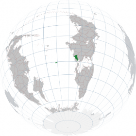
 Location of Sedunn (dark green) | |
| Capital and largest city | Grovne 26°15'S 24°55'E |
| Official languages | Sedunnic |
| Ethnic groups | 93.2% Sedunners 6.8% other |
| Religion | 84.8% Non-religious 10.1% Christian 1.1% Neo-Limevv 0.9% Muslim 3.1% Other/unknown |
| Demonym(s) | Sedunnic · Sedunner |
| Government | Unitary parliamentary republica |
• Dellm (King)a | Vimmru II |
• Speaker of the Parliament | Gety Flutslok |
| Legislature | Mannared |
| Formation | |
• Consolidation | c. 700 BC |
• Provincehood of Remetull Islands | 14 July 1651 |
| Area | |
• Total | 93,493 km2 (36,098 sq mi)b |
• Water (%) | 1.4 |
| Population | |
• 2020 estimate | 17,865,976 |
• Density | 191/km2 (494.7/sq mi) |
| GDP (nominal) | 2020 estimate |
• Total | $1.09 trillion |
• Per capita | $60,793 |
| Gini (2019) | 25.1 low |
| HDI (2019) | 0.949 very high |
| Currency | Sedunnic tenn (TEN) |
| Time zone | UTC+2 (CBT) |
| Date format | dd/mm/yyyy CE |
| Mains electricity | 230 V–50 Hz |
| Driving side | right |
| World Forum Code | SD |
| Internet TLD | .sd |
| |
Sedunn (Sedunnic: Sedunn ['seːd̪ɵ̞n̪ː]), officially the Kingdom of Sedunn (Sedunnic: Devtoved Sedunn ['d̪eːvt̪uːveːd̪ 'seːd̪ɵ̞n̪ː]), is a sovereign parliamentary republic whose territory consists of mainland Sedunn (also called Bailtem-Sedunn) in the southwestern corner of Bailtem and the overseas province Remetull Islands in the South Pacific Ocean. Mainland Sedunn is situated between the Limmvasd and Jytann mountain ranges and the South Pacific Ocean and the Mediterranean Sea, bordered by Stoinia to the north, Ezervulge to the east, Jytann to the south-west and Ikoania to the southeast. It is characterized by an arable rolling landscape with a cool-summer Mediterranean climate in its coastal and central regions and steep mountains with varying climates towards the northern and eastern borders. Situated in the South Pacific Ocean, the Remetull Islands have a humid subtropical climate. Mainland Sedunn has a total area of 83,502 km2, and including the Remetull Islands, Sedunn has a total area of 93,493 km2, and a population of almost 17.9 million (as of 2021). Sedunn is a unitary parliamentary constitutional republic with its capital in Grovne, the country's largest city and main cultural and commercial centre. Other major cities are Flered, Goends and Lomared .
Sedunn emerged as a unified nation at the end of the Mediterranean Iron Age around 700 BC. Several important Duric cities had emerged in what is today's mainland Sedunn, predominantly south of the Setru River. The cities were part of an extensive trade network stretching across the surrounding mountains and the Mediterranean Sea. They were in fierce competition with each other, but also with other large cities in the trade network. To consolidate their resources and end the internal Duric competition, the five most powerful city states chose a common leader, a king, to rule the lands which the Dures inhabited, thereby initiating a consolidation process that was to incorporate all lands inhabited by the Dures, forming the elective monarchy of Sedunn. The country remained a competitive part of the intricate Mediterranean trade network and a major maritime power into the early middle ages. Some time not long after the unification process, The Remetull Islands were discovered and settled.
Between the 15th and the 19th centuries, Sedunnic explorers and merchants expanded Sedunn's trade network to Cordilia and Crabry, then to all the other continents, asserting itself as a major naval and trade power. This lead to several conflicts and wars with other nations. Sedunn notably never tried to conquer or colonise new land and remained a democracy.
In Peter I's War between 1884 and 1885, Ezervulge invaded Sedunn to attempt installing a regime more favourable to king, fearing that Sedunnic liberal ideas would gain more ground in Ezervulge, but Ezervulge was decisively defeated. In 1915 imperialist Ubesii declared war on Sedunn with the same goals. The war ended inconclusively, but Ubesii failed to achieve its goals. During the Great War, Sedunn was part of the Democratic Alliance. After these costly wars, many Sedunners started to question what was called the "extraversion" and Sedunnic involvement in international affairs. As an effect Sedunn employed a non-interference policy until the beginning of the 21st century where the policy was reversed. Sedunn hosted the summit which founded the World Forum, and Grovne is the seat of its Headquarters and the Assembly. The headquarters of the CPSC is also located in Sedunn. The country plays a prominent role in regional and global economic, military, cultural and diplomatic affairs, being a strong proponent of international law and democracy.
Sedunn has a well developed welfare system that provides universal health care and tertiary education. It ranks very high in quality of life, health, education, protection of civil liberties, economic competitiveness, equality, prosperity and human development. The Sedunnic mixed-market economy is export-oriented and is an important producer of ships, vehicles, machinery, pharmaceuticals, electronics and various agricultural products. Sedunn is a secular state.
Etymology
By the end of the Iron Age, the leadership of several important Sedunnic cities consolidated their power and elected a king to rule all the lands that they controlled, which were located between the South Pacific Ocean, the Mediterranean Sea, the Limmvasd and Jytann mountain ranges. The new nation became known as Skayimmend Seidŭned (the Realm/Land Between). In later phonetic changes, all diphthongs disappeared, and "realm/land" was dropped from the name, resulting in today's Sedunn.
The formal name of Sedunn in Sedunnic is Devtoved Sedunn, which roughly could be translated as the Democracy Sedunn. However, in Austral the formal name is Kingdom of Sedunn, due to the fact that (elected) kings and queens ruled Sedunn when it came into contact with nations speaking Austral. A more correct term today would be Republic of Sedunn, since the kings/queens have no more power than ordinary prime ministers in parliamentary republics.
History
Prehistory
Antiquity
Unification
Middle ages
Early modern
Karnetvorian unification
Trade wars and the Great War
Post-war
Recent
Geography
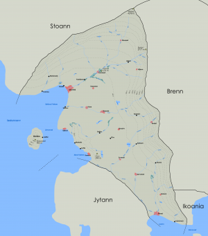
The territory of Sedunn includes an area on the southwestern corner of Bailtem, referred to as the mainland or Bailtem-Sedunn, and the Remetull archipelago to the west in the South Pacific Ocean. The mainland includes the island of Deri in the Sea of Sedunn. The mainland is located between the Mediterranean Sea, the South Pacific Ocean, and the Limmvasd and Jytann mountain ranges. The mainland lies between latitudes 24° and 29° S, and longitudes 23° and 28° E. The Remetull Islands lie between latitudes 30° and 31° S, and longitudes 8° and 12° E. Sedunn's northern and eastern borders are roughly delimited by the Limmvasd watershed. To the north it borders Stoinia, to the east Ezervulge, and to the southeast Ikoania. To the southwest, Sedunn borders Jytann along the Gobyv and Taksd rivers. These rivers are artificially connected by canals and locks, forming the Ilva Canal which makes it possible to save time by sailing directly from Myttenst to Flered instead of going around the Jytann peninsula.
The northern and eastern landscapes of the mainland are mountainous and indented by river valleys, whereas the central landscapes are characterized by rolling plains. The highest point is located on Mount Vetres at 4378 m or 14,634 ft. Another well-known mountain is Mount Skolyt at 3717 m or 12,195 ft. The lowest elevation, called Tapne, is in the bay of the Lomann marshlands, near Lomared, at −2.41 m (−7.91 ft) below sea level. Mainland Sedunn has an extensive river system consisting of the five major rivers Setru, Dybd, Taksd, Gobyv and Avna. The Dybd is Sedunn's longest river at 219 km or 136 miles. It empties in the Sea of Sedunn. The coastlines offer contrasting landscapes: coastal cliffs such as the Gra Coast and Essela Bay, and wide sandy plains on the south coast.
Most of the Remetull islands are characterised by a mountainous interior and sandy shores. The largest island, Piel, has a plain, the Skor Valley in the southwest, indented by the rivers Frodd and Skor. The mainland is predominantly agricultural with increasing forest coverage northward and in the mountains. The Remetull archipelago is largely deforested.
The country's total area is 93,493 square kilometres (36,098 sq mi), of which roughly 1.4% is water.
Climate
The cool Aiksi Current from Keyli, upwelling and high altitudes give Mainland Sedunn a mainly Mediterranean climate, predominately Csb, but Csa in certain areas along the coasts with low elevation, and thin bands of Csc at higher altitudes. Higher altitudes are characterised by a temperate maritime climate (Cfb), and at the highest altitudes, a tundra climate (ET). In most of mainland Sedunn, summers are warm (but not hot) and dry. During the summer the daily average temperature is 15-27°C, with no average monthly temperatures above 22 °C (72 °F). Winters are rainy and can be mild to chilly. Sometimes snow can fall on these areas. At higher altitudes, such as in the Limmvasd Range, temperatures are significantly cooler. Winters are cold and snow is frequent.
The Remetull islands have a humid subtropical climate (Cfa) characterized by hot and humid summers with frequent thunderstorms, and foggy, damp and chilly winters with sudden bursts of frost and snow. At higher altitudes, the climate is characterised by continental types (Dfc, Dfb/Dsc, Dsb) with cooler summers and cold winters with frequent snow. Typically the daily average high temperature is 26-30°C and the low temperatures around 20°C during the summer. During the winter the daily temperature ranges from around 3-10°C. at higher altitudes the temperature varies more.
Flora and fauna
Due to its geographical location between the South Pacific Ocean and the Mediterranean Sea, proximity to Bareland and due to its varying climate, Sedunn has a high rate of biodiversity on land and at sea. The tivus, a forest lion, is a notable endemic species. The natural potential vegetation of the coastal and central regions of Sedunn includes evergreen trees such as eucalyptus, pine and cypress, deciduous trees such as oak and sycamore, and fruit trees like olive, grape and walnut. At higher altitudes, broadleaf trees are more common. The forests have been extensively cleared since antiquity for growing crops and other agricultural products. Remaining forests account for roughly 32% of the land area. Sedunn is notable for several large marshlands and forested wetlands, especially in the Setru valley.


